New in Flurosense: on-demand high-resolution satellite imagery
Sentinel 2 satellites acquire 10 m/px imagery of your farm without you needing to order it. For management of orchards, vineyard and high-value crops on drip-irrigation systems low-resolution imagery has limited use. In 10 m/px image, you can not see individual trees or spot irrigation leaks, but there are other satellites that provide high-resolution (<1m/px) imagery to address these needs globally!
As mentioned in the previous post, fixed-wing aircraft or drones might not be available or cost-effective enough depending on the country you are in or the size of your farm. Note: you can order fixed-wing aircraft imagery and/or drone imagery through FluroSense in the USA, Australia, Brazil, Argentina.
That’s why we see the high-resolution (< 1 m/px) satellite imagery growing in demand amongst our customers, thanks to its global availability, standardised quality and responsiveness (more on this later).
Medium and high-resolution satellite imagery
At FluroSat, driven by the desire to address our user’s needs, we have now provided our customers managing orchards, vineyard, and high-value crops on drip-irrigation systems with an easy way to order high-resolution satellite imagery to access the much-needed operational insights!
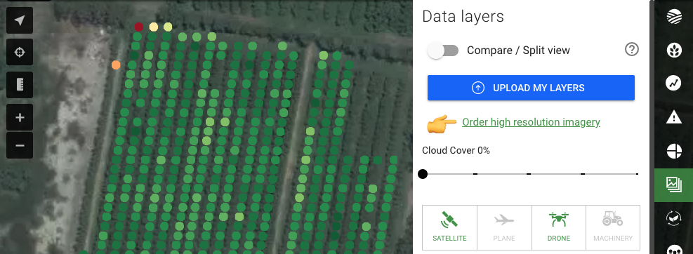
As a FluroSense user, you can access on-demand satellite imagery, such as
- high-resolution imagery (RGB+NIR, <50 cm) – “tasking”, i.e. placing order for future imagery acquisition
- medium-resolution imagery (RGB+NIR, 3m) – retrieving the image from the imagery archive.
RGB imagery, shown above gives you a “bird’s eye view”, and RGB+NIR bands together allow us to generate NVDI/biomass index. For more details on vegetation indices, please, check out the short explanation video here.
Best uses of high-resolution imagery
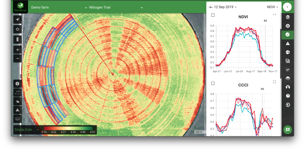
1. Monitoring trials across crop types
Value of any trial is closely linked to our ability to capture and demonstrate its effect. Plot designs often have individual areas of interest much smaller than 10 m/33 ft, and hence require high-resolution imagery for monitoring. The high-resolution images can be scheduled for future acquisition at a set point in time to align with the key growth stages or operational tasks.
To make trial monitoring even simpler, you can upload your plot designs directly to FluroSense, where all plots that have the same treatment/planting parameters can be connected into a group, allowing you to monitor the average performance of the application across all the plots with the same rate at once, and easily benchmark them against each other.
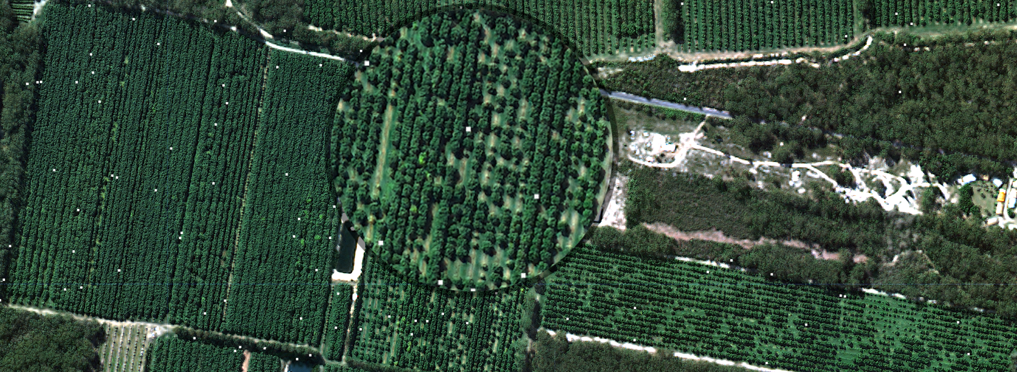
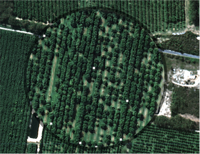
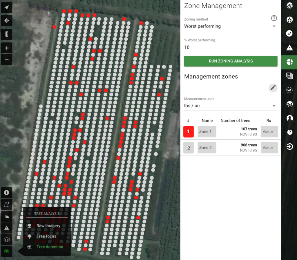
2. Tree health analytics
Detection of individual trees in orchards and groves requires sub-meter high-resolution imagery, which can be ordered through FluroSense for farms anywhere in the world. Once the trees have been identified, the orchard analysis can be easily performed on an zone, block or farm level.
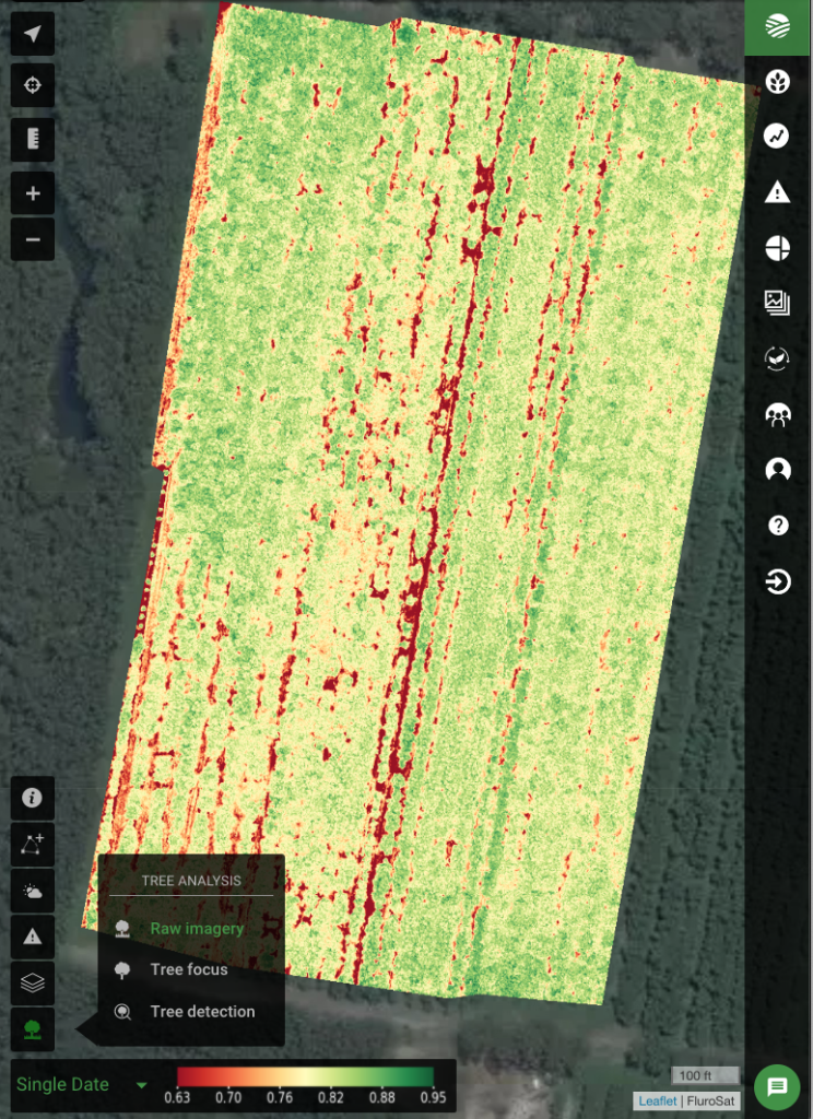
Raw NDVI imagery layer 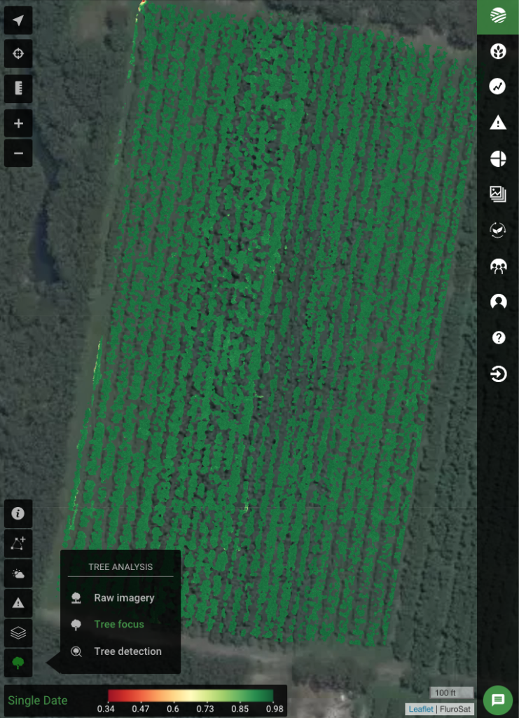
“Soil free” canopy layer 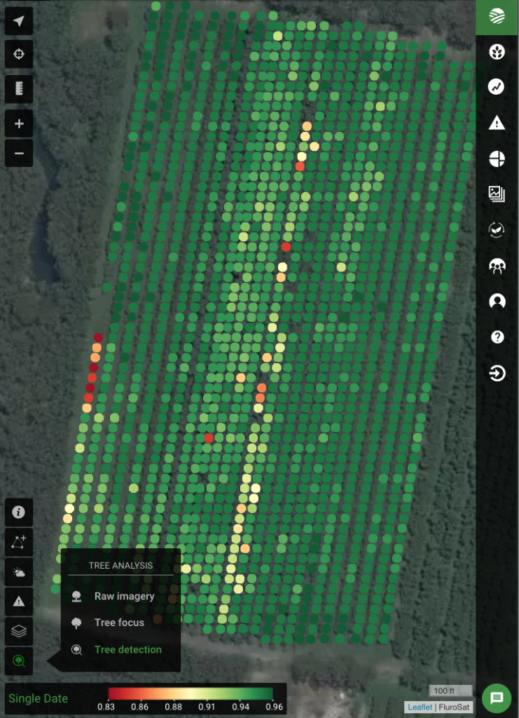
Individual tree health
What is more important, however, is being able to quickly make decisions on the tree health metrics derived from imagery, such as identifying the 10% worst performing trees in the block or benchmarking the blocks to see where there might be issues with the irrigation systems.
Ordering high-resolution satellite imagery has never been easier!
We have made it extremely easy for you to place orders for high-resolution satellite imagery. You can either do it
- right here by hitting “Request a quote” button
- or in FluroSense, from your “Data layers” tab or User > Integrations
When placing the order, you can let us know the optimal date(s) you would like to get imagery over your fields, and you will shortly get a quote for approval!
High-resolution imagery buyer’s guide
Want to learn more? Download the high-resolution imagery guide that demonstrates optimal field configurations, pricing, and other details that will help you determine if the high-resolution satellite imagery is a good fit for your farm.
We know that being a farmer or a crop consultant does not require you to be an imagery expert, and so you can just call on our expertise anytime! So if you are not sure, what data source is right for you, and your farm our friendly team of agronomists is just a click away and is always happy to help you assemble or pick the solution/package that makes the most sense for your agribusiness.
Recent Posts
FluroSat Acquires Dagan to Unlock Potential and Profitability of Resilient Agriculture
Regrow Is First Single Platform to Systemize, Scale and Monetize …Read More »
800+ Participant Webinar Proves the Ag World Is Ready to Embrace Regenerative Farming and Carbon Markets
By Adrian White | 2.15.2021 How do we get carbon …Read More »